
Understanding Earth's complex climate system requires an integrated approach that captures the intricate connections between land, oceans, and atmosphere. By combining Climate Change Initiative datasets of Essential Climate Variables (ECVs), state-of-the-art research is accelerating the knowledge behind Earth’s energy, water, and carbon cycles. Collectively, the data provide the evidence record to understand the changing planet and unlock key climate science challenges.
These variables, like Clouds, Sea Ice, or Fire, have been agreed and defined by science and policy communities via the Global Climate Observing System (GCOS). A total of 56 variables are deemed sufficient to fully characterise the climate – almost two thirds are addressed by satellites. Research teams contributing to ESA’s Climate Change Initiative are developing satellite records that address an expanding suite of ECVs, which currently stands at 28 and stretches back in time more than five decades.
To harness the full power of these datasets, six new research and development projects have been established with the aim of addressing key climate challenges by combining satellite-derived data records of several ECVs. Their goal is to close critical knowledge gaps identified by the international scientific community, including the World Climate Research Programme, the Global Climate Observing System, and the Intergovernmental Panel on Climate Change (IPCC). In doing so, they are supporting progress towards the goals of the United Nations Framework Convention on Climate Change Paris Agreement.
Assessing changes in the Arctic Ocean’s freshwater
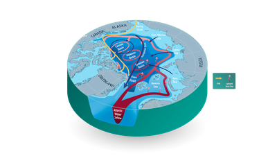
Changes in the Arctic Ocean’s freshwater is a critical, yet poorly constrained climate component that disrupts global ocean circulation with the risk of profound climatic consequences. ARCFRESH is a Cross-ECV project that seeks to deepen our understanding of Arctic freshwater processes by combining Earth Observation data records of seven ECVs, like River Discharge, Snow, and Glaciers. Using rigorous uncertainty analysis across all datasets, the project delivers an enhanced Earth Observation database for the Arctic, enabling climate modellers and researchers to advance Arctic Ocean research.
Examining links between people, water, and forests
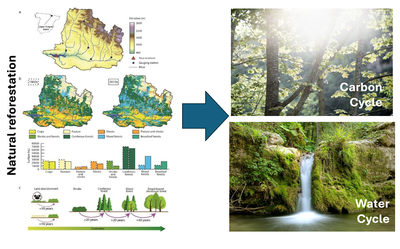
In recent decades, the Mediterranean region has emerged as a critical hotspot for both climate change and land abandonment. In Europe, approximately 120 million hectares of land have been abandoned due to socio-economic factors and therefore experienced widespread natural reforestation. The primary aim of GLANCE is to quantify the combined effects of climate change and agricultural land abandonment on forest carbon dynamics, water and energy cycles in the Mediterranean region. To do so, researchers are analysing more than 30 years of data from the ESA Climate Change Initiative, while applying different tools and methods to accurately assess the uncertainties of these datasets. They are also employing trend analysis, drought indices, and climate elasticity methods to uncover the impacts.
Predicting glaciers response to climate change

The Karakoram mountain range presents a unique climate paradox, where glaciers have remained stable or even grown in some areas, defying the global trend of glacial retreat. Using Earth Observation data, the Karakoram Anomaly Cross-ECV project investigates spatial and temporal patterns of glacier mass change as well as glacier sensitivity to climate variability and change. The project also analyses regional trends using multiple ECV data records like Cloud Cover, Snow Cover, and Lakes to determine whether the anomalies observed in the Karakoram are consistent with broader climate patterns and align with the available data.
Monitoring the global energy cycle
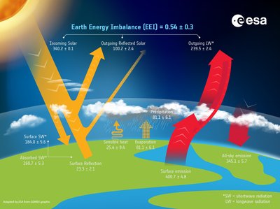
Understanding how the Sun’s energy drives the global energy cycle and shapes the climate has been a central focus of scientific research for nearly two centuries. The MOTECUSOMA project uses satellite data to simultaneously study the Earth Energy Imbalance and surface air temperature over the past three decades. Earth Energy Imbalance occurs when the Earth absorbs more energy than it releases back to space, resulting in global warming. The project’s objectives include developing tools to diagnose changes in these critical climate indicators, linking these changes to the broader Earth system, as well as identifying and quantifying processes driving energy cycle shifts due to human activities.
Understanding Aerosol-Cloud Interactions’ role in climate cooling
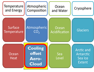
Interactions between aerosols and clouds are one of the most uncertain aspects of climate science, yet crucial for understanding Earth's energy balance. By utilising multiple Essential Climate Variable data products developed through ESA’s Climate Change Initiative, the SATACI project aims to improve understanding of these interactions and their impact on Earth’s climate. The science exploitation study focuses on two main activities: Analysing the effects of aerosol-cloud interactions on liquid clouds and cloud glaciation as well as conducting a feasibility study for a new aerosol-cloud climate indicator to monitor the cooling effects of aerosols and clouds. By combining satellite data, advanced retrieval algorithms, and climate modelling, the project seeks to enhance our knowledge of aerosol-cloud interactions and their role in radiative forcing. This will contribute valuable insights to IPCC assessments and global climate monitoring efforts.
Determining the effects of extreme fires on the atmosphere and climate
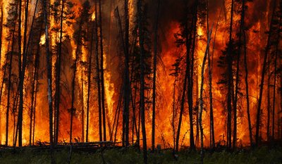
Fires play an important role in the Earth system, affecting the climate, the atmosphere, vegetation, soil and societal resources. Extreme fires are particularly significant as they cause the majority of fire-related damage, despite representing only 2 per cent of all fires. However, they remain poorly defined. Taking a holistic approach, the XFires project uses ECV data records developed through ESA’s Climate Change Initiative to define and differentiate extreme fires from ‘normal’ fires. Using machine learning models and case studies, the project will assess the causes, frequency, and predictability of extreme fires, as well as their impact on the atmosphere, climate, vegetation, and human health. By addressing these knowledge gaps, XFires will also help inform the IPCC and climate adaptation policies.