
Little Picture - Arctic sea ice extent
A little picture by James Williams
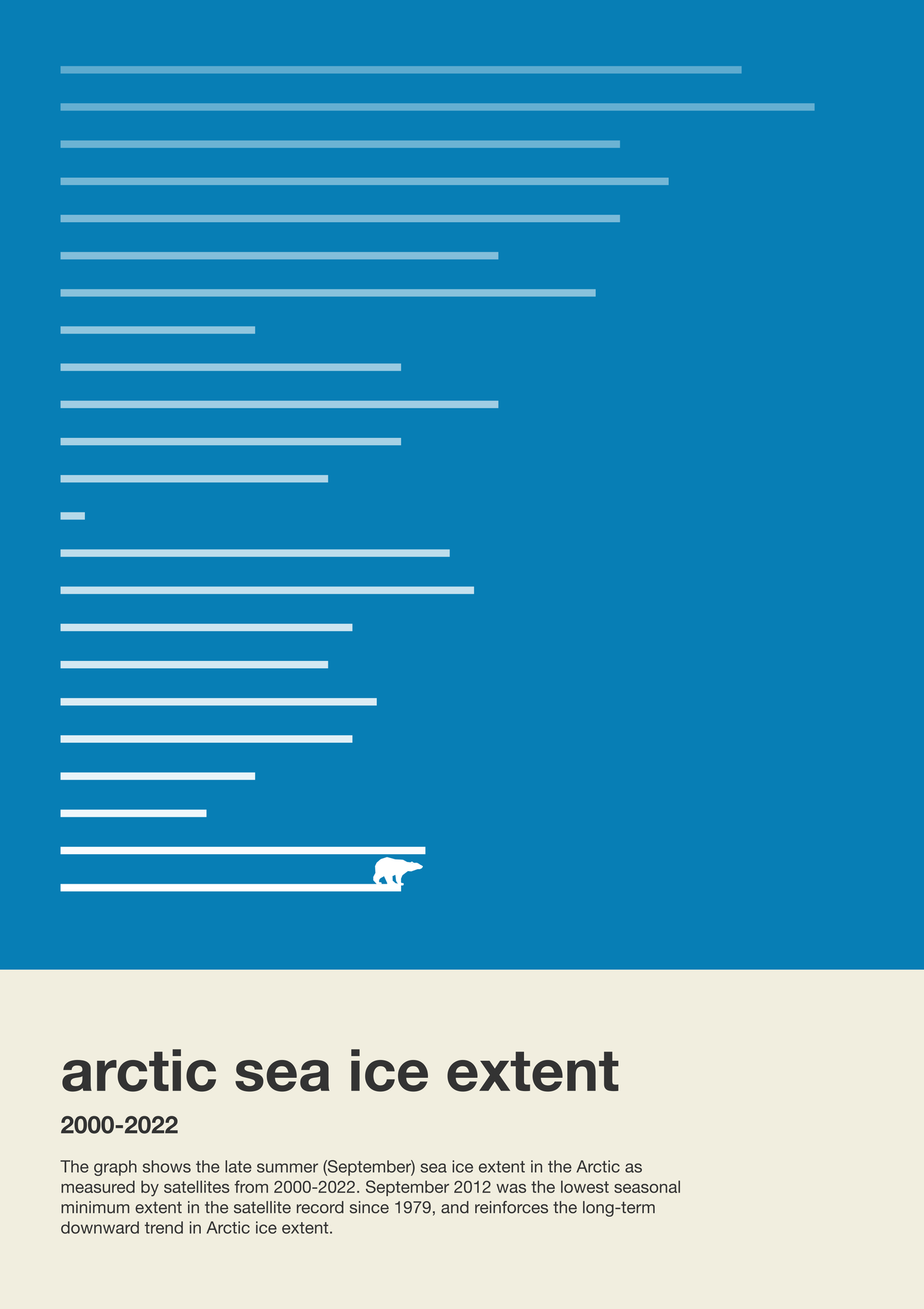
The Little Picture shows the late summer (September) sea ice extent in the Arctic as measured by satellites from 2000-2022.
About
The Little Picture shows the late summer (September) sea ice extent in the Arctic as measured by satellites from 2000-2022.
Sea ice variability is a key indicator of climate change in the polar regions and is considered as one of 54 Essential Climate Variables by the Global Climate Observing System that are used to characterise the Earth system. Warming resulting from greenhouse gas forcing is a main cause of this decline with model based studies - validated by satellite observations - suggesting that sea ice will cease to practically exist during Arctic summer sometime during the 21st century, even in a low emissions scenario.
Data
The Little Picture uses late summer (September) sea-ice extent given in million km² in the Arctic as measured by satellites from 1979-2022 from this file - https://github.com/littlepictures/datasets/tree/main/arcticSeaIceExtent and was generated from operational data available via the EUMETSAT Ocean and Sea ice Satellite Application Facility (OSI SAF).
Script
James used the JavaScript SVG Chart library D3.js to create the whole visualization from scratch, and then used an additional JavaScript library called d3plus-text which offered the ability to work with text a little easier in SVG. After exporting the SVG chart, he used the tool SVGOMG for formatting and 'prettifying' the Little Picture.
Licence
This Little Picture is published under CC BY-SA 4.0 licence.
The big picture
The European Space Agency (ESA), the European Centre for Medium-Range Weather Forecasts (ECMWF), and the European Organisation for the Exploitation of Meteorological Satellites (EUMETSAT) work closely together to measure, process & make space-derived information about the climate available.
ESA
The mission of the Climate Change Initiative (CCI) is to realise the full potential of the long-term global Earth Observation archives that the European Space Agency (ESA), together with its Member states, has established over the past 40 years, as a significant and timely contribution to the climate databases required by the United Nations Framework Convention on Climate Change. The ESA Climate Office provides a free & open CCI data facility bringing together ECV data from across its twenty-seven climate science projects, including a CCI Data Standards and a CCI Toolbox.
ECMWF
The Copernicus Climate Change Service (C3S) supports society by providing freely available authoritative information about the past, present and future climate in Europe and the rest of the World. C3S is one of the six thematic information services provided by the Copernicus Earth Observation Programme of the European Union, and has been entrusted by the European Commission to the European Centre for Medium-Range Weather Forecasts (ECMWF). One of the core components of C3S includes the Climate Data Store (CDS). This is a one-stop shop for climate information. It provides free and easy access to a wide range of climate datasets via a searchable catalogue. A freely available online toolbox allows users to build workflows and applications suited to their needs.
EUMETSAT
EUMETSAT operates missions both to provide weather and climate data for its member states, and as an entrusted entity under the Copernicus programme. Several missions are operated collaboratively with ESA, providing complimentary expertise and data processing, to process and distribute land, marine, and atmosphere relevant products for users. Data from EUMETSAT operated missions is frequently available in near-real-time, facilitating rapid monitoring and forecasting. Via EUMETCast, the EUMETSAT Data Services, or WEkEO, users can access data in ways that suit their needs. The data is used by the EUMETSAT satellite applications facilities, as well as across the various Copernicus Services.
next