
Little Picture - Urban and Rainforest regions in Brazil
A little picture by Sacha Berna
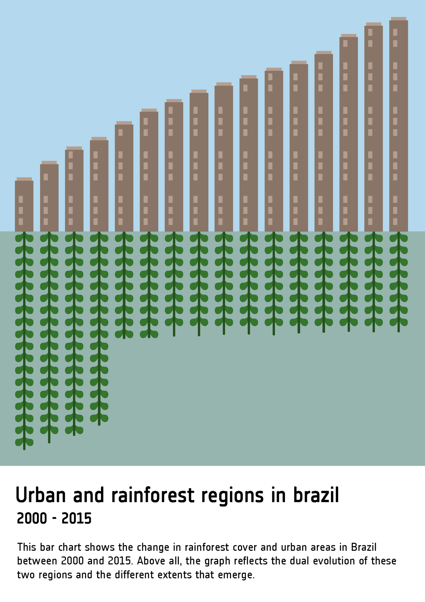
This bar chart represents change in rainforest cover and urban area across Brazil between 2000 and 2015. The creator, scientific illustrator Sacha Berna, used Land Cover data available from ESA's Climate Change Initiative to show the evolution of rainforest areas and urban areas. She uses a bar graph system to show how quickly one data set (urban regions) changes in relation to the other (rainforest regions).
In her own words:
'The aim of this image is above all to draw a visual portrait of two regions that are evolving at different rates and in unequal ways. Above all, it raises questions about the relationship between urban development and vegetation in a country with the largest forested area in the world.'
About
The Little Picture represents change in rainforest cover and urban area across Brazil between 2000 and 2015. Land Cover is a key aspect of the climate system and is important for the understanding of climate and its vulnerability to changes on the surface of the Earth - it is considered as one of 54 Essential Climate Variables by the Global Climate Observing System.
About the creative
This Little Picture was generated by scientific illustrator, Sacha Berna. She sees the aim of her day job is to help people understand science through images and to convey scientific information using a variety of graphic media. Depending on the project, the aim of this speciality is to build bridges between disciplines, reach out to the public or raise awareness.
Generating this Little Picture was an opportunity to try out data visualisation, which sits at the crossroads between the illustration and information and highlight the wealth of data provided by satellites over the years.
Judges commendations
- 'Clear communication of the issue'
Data
The Little Picture uses data Land Cover data from the ESA Climate Change Initiative (Defourny, P. (2019): ESA Land Cover Climate Change Initiative (Land_Cover_cci): Global Land Cover Maps, Version 2.0.7. Centre for Environmental Data Analysis, date of citation. https://catalogue.ceda.ac.uk/uuid/b382ebe6679d44b8b0e68ea4ef4b701c).
Specifically, a Brazil subset of this dataset was used for rainforests and urban regions in Brazil.
Code
There were no scripts used to build this Little Picture. The entire image was created using Adobe Illustrator, with the graphics tool and vector-based illustrative processing. The leaves and windows have been treated in the form of rasters and follow a logic in which they adapt to the size of the graph.
Licence
This Little Picture is published under CC BY-SA 4.0 licence.
The big picture
The European Space Agency (ESA), the European Centre for Medium-Range Weather Forecasts (ECMWF), and the European Organisation for the Exploitation of Meteorological Satellites (EUMETSAT) work closely together to measure, process & make space-derived information about the climate available.
ESA
The mission of the Climate Change Initiative (CCI) is to realise the full potential of the long-term global Earth Observation archives that the European Space Agency (ESA), together with its Member states, has established over the past 40 years, as a significant and timely contribution to the climate databases required by the United Nations Framework Convention on Climate Change. The ESA Climate Office provides a free & open CCI data facility bringing together ECV data from across its twenty-seven climate science projects, including a CCI Data Standards and a CCI Toolbox.
ECMWF
The Copernicus Climate Change Service (C3S) supports society by providing freely available authoritative information about the past, present and future climate in Europe and the rest of the World. C3S is one of the six thematic information services provided by the Copernicus Earth Observation Programme of the European Union, and has been entrusted by the European Commission to the European Centre for Medium-Range Weather Forecasts (ECMWF). One of the core components of C3S includes the Climate Data Store (CDS). This is a one-stop shop for climate information. It provides free and easy access to a wide range of climate datasets via a searchable catalogue. A freely available online toolbox allows users to build workflows and applications suited to their needs.
EUMETSAT
EUMETSAT operates missions both to provide weather and climate data for its member states, and as an entrusted entity under the Copernicus programme. Several missions are operated collaboratively with ESA, providing complimentary expertise and data processing, to process and distribute land, marine, and atmosphere relevant products for users. Data from EUMETSAT operated missions is frequently available in near-real-time, facilitating rapid monitoring and forecasting. Via EUMETCast, the EUMETSAT Data Services, or WEkEO, users can access data in ways that suit their needs. The data is used by the EUMETSAT satellite applications facilities, as well as across the various Copernicus Services.
next